


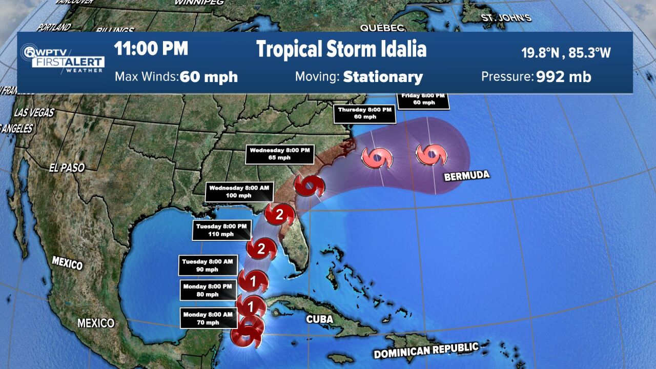
WEST PALM BEACH, Fla. — Tropical Storm Idalia is forecast to become a Category 2 hurricane by Wednesday morning as it lifts north into the Gulf of Mexico.
Storm surge and hurricane watches have been issued for portions along the Gulf Coast of the state.
Idalia is forecast to become the third hurricane early Tuesday, joining Don and Franklin, which now is in the Atlantic Ocean.
The ninth named storm of the 2023 Atlantic hurricane season is forecast to move over the eastern Gulf of Mexico on Monday and Tuesday and approach the northeast Gulf Coast late Tuesday. It is projected to make landfall near Florida's panhandle and big bend on Wednesday morning as a Category 2 storm.
Thereafter, it's on track to weaken into a tropical storm by the end of the work week as it brushes by Georgia and then into the Carolinas.
While the center of the storm will stay away from the local viewing area, impacts will be felt even outside of the center.

State
DeSantis to residents along tropical storm path: 'Be prepared'
"As it looks our area will be spared the worst of the rain and wind," WPTV First Alert Weather meteorologist Kate Wentzel said. "However, it is shaping up to be a wet week with some outer rain bands likely moving through late Tuesday and Wednesday. We have to be on the lookout for weak tornadoes embedded in the bands."
Gov. Ron DeSantis on Saturday declared a state of emergency in 33 of the 67 counties along Florida's Gulf Coast, ranging from Fort Myers in the southwest to Panama City in the panhandle.
Deep tropical moisture moves in starting Monday and sticks around through Friday, so expect showers and storms each day.
The worst of the weather will be on Tuesday and Wednesday as the outermost rainbands associated with the tropical disturbance push into the area.
There is a possibility of a tropical storm watch for Okeechobee County.
Winds are expected to pick up to 15-25 mph and gusts up to 30-35 mph on Tuesday and Thursday.
The strongest winds will occur on Wednesday with gusts up to 35-40 mph. Tropical storm force winds are 40 mph and above.
Rainfall totals in portions of the west coast, the panhandle and southern Georgia will be 3 to 6 inches from Tuesday into Wednesday, with isolated higher totals of 10 inches, NHC said.
TRACKING THE TROPICS: Hurricane Center | Hurricane Guide
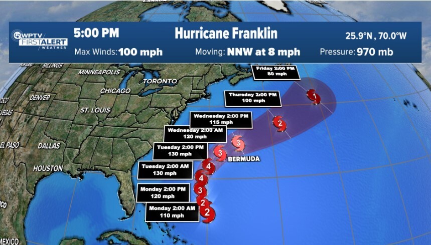
Hurricane Franklin is on track to strengthen into a Category 3 hurricane by Monday but not forecast to affect the United States.
But the NHC warns of "life-threatening surf and rip currents along the East Coast of the United States."
This system likely will impact Bermuda.
In the 5 p.m. AST update, Franklin was about 320 miles north-northeast of Grand Turk Island and about 535 miles southwest of Bermuda with maximum sustained winds of 100 mph. Franklin was moving northwest at 8 mph.
Elsewhere in the tropics, a tropical wave is forecast to emerge off the coast of Africa where it has a 20% chance for tropical development over the next seven days.


