


WEST PALM BEACH, Fla. — Tropical Storm Harold formed overnight Tuesday and made landfall in southern Texas as a weak tropical storm.
Radar from Brownsville, Texas, indicated that the center of Harold made landfall on Padre Island around 10 a.m. Central time.
Later Tuesday, Harold dropped to a depression.
According to the 10 p.m. CDT advisory from the National Hurricane Center, Harold was about 45 miles west-southwest of Laredo, Texas, and about 480 miles southeast of El Paso.
Harold has maximum sustained winds of 35 mph and is moving west-northwest at 18 mph.
Harold is expected to produce rainfall amounts of 1 to 2 inches, with isolated higher amounts of 6 inches, across South Texas through early Wednesday. Isolated instances of flash flooding will be possible.
TRACKING THE TROPICS: Hurricane Center | Hurricane Guide
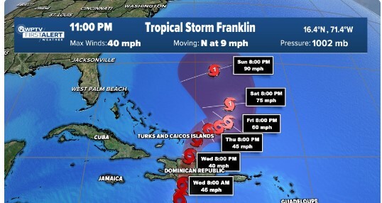
Meanwhile, Tropical Storm Franklin on Tuesday is producing rain bands that are sweeping across the central Caribbean from Puerto Rico to the Dominican Republic and Haiti. The NHC warns of "life-threatening flooding possible on Hispaniola through Wednesday."
In the 11 p.m. EDT update, Franklin was about 175 miles south-southwest of Santo Domingo, Domician Republic with maximum sustained winds of 40 mph. Harold was traveling northwest at 9 mph.
A turn to the northwest if forecast Thursday. On the forecast track, the center of Franklin is expected to approach the southern coast of Hispaniola tonight, cross the island on Wednesday, and then emerge over the southwestern Atlantic waters late Wednesday.
Five to 10 inches of rain are forecast for parts of Hispaniola, with isolated amounts of up to 15 inches. Puerto Rico could get 1 to 3 inches of rain, but up to 4 inches are possible.
Franklin with then turn northeastward, away from the Bahamas and Turks and Caicos, but some indirect impacts may still reach the islands.
Florida will not be impacted by Franklin.
Tropical Storm Gert became a post-tropical remnant low late Tuesday morning. It was about 230 miles east-southeast of the Northern Leeward Islands with maximum sustained winds of 30 mph and was traveling west-northwest at 7 mph.

Finally, two areas in the far eastern Atlantic have a low to medium chance for development over the next seven days.
Invest 92 is a wave producing disorganized showers and thunderstorms a several hundred miles west of the Cabo Vero Islands. A tropical depression could form later this week or the weekend as it moves west-northwest. Over seven days there is a 40% chance of formation.
The remnants of former Tropical Storm Emily are over central tropical Atlantic several hundred miles east-northeast of the Leeward Islands. This system could regenerate into a tropical depression late this week or the weekend when the system moves northward over the subtropical Atlantic. Over seven days there is a 50% chance of formation again.


