



The Atlantic is beginning to show more signs of life as we move deeper into hurricane season.
The National Hurricane Center is currently tracking two tropical waves moving across the eastern and central Atlantic and also a trough of low pressure a few hundred miles west-northwest of Bermuda.
TRACKING THE TROPICS: Hurricane Center | Hurricane Guide
At this time, none of the systems pose a threat to Florida or the United States, but both will be monitored as they continue westward over the coming days.
The disturbance near Bermuda is expected to dissipate quickly as it moves over cooler ocean waters. It only has a 10% chance of development over the next seven days.
The disturbance in the central tropical Atlantic has a 20% chance of development over the next seven days. Environmental conditions may allow for some gradual organization early this week before stronger upper-level winds become less favorable later in its journey.
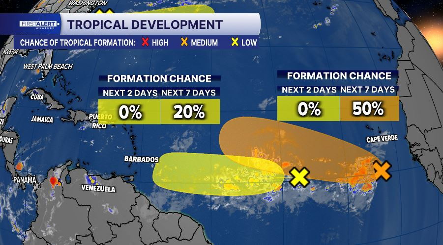
A second tropical wave has emerged off the west coast of Africa. Forecast conditions appear more supportive for development, giving this system a 50% chance of becoming a tropical depression within the next seven days as it moves west across the eastern Atlantic.
While there are no immediate concerns for Florida, this increase in tropical activity is not unusual. Climatologically, the Atlantic hurricane season ramps up quickly during August and reaches its peak around September 10.
This serves as a reminder that now is an excellent time to review your hurricane plan, check your emergency supplies, and make sure you have multiple ways to receive weather alerts.
The WPTV First Alert Weather Team will continue monitoring the tropics around the clock and provide updates if any system begins showing signs of becoming a concern for South Florida.


