


WEST PALM BEACH, Fla. — One tropical storm remains in the Atlantic basin while two others dissipated Monday and a depression in the Gulf of Mexico may intensify.
Tropical Storm Franklin is a strong and healthy system that will reach the Hispaniola, including Haiti and Dominican Republic, by Wednesday, the National Hurricane Center said.
Two other tropical storms dissipated Monday. Emily became a remnant and Gert dissipated into a depression. Gert had become a tropical storm earlier in the day.

TRACKING THE TROPICS: Hurricane Center | Hurricane Guide
In the 11 p.m. National Weather Service update, Franklin is located 275 miles south of Santo Domingo, Dominican Republic with maximum sustained winds of 50 mph. Franklin was moving 7 mph north-northwest and should turn northward Tuesday. On the forecast track, the center of Franklin is forecast to reach the southern coast of Hispaniola by Wednesday.
A tropical storm warnings are in effect for the entire coasts of Dominican Republic from Haiti border eastward to Isla Saona and Haiti from Anse d'Hainault eastward to the Dominican Republic border.
WATCH: WPTV First Alert Weather tropical update
In the 11 p.m. EDT update, Gert has maximum sustained winds of 30 mph and was moving west-northwest at 7 mph. Gert was about 320 miles east of the Northern Leeward Islands.
Gert or its remnants should turn northwestward overnight or Tuesday.
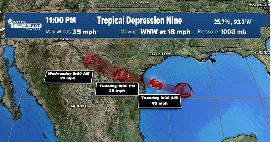
Meanwhile, Tropical Depression 9 in the Gulf of Mexico that affected South Florida over the weekend is forecast to bring gusty winds and heavy rains in South Texas beginning overnight.
The depression is about 260 miles east-southeast of Mansfield, Texas, with maximum sustained winds of 35 mph. It is traveling west at 18 mph.
The system is forecast to move inland over South Texas by midday Tuesday.
A tropical storm warning has been issued for the mouth of the Rio Grande to Port O'Connor, Texas. A tropical storm watch has been issued from Port O'Connor northward to Sargent. Rainfall amounts of 3 to 5 inches, with isolated higher amounts of 7 inches, are possible on Tuesday and Wednesday.
The next storm name is Harold.

Finally, a wave (invest 92) located west of the Cabo Verde Islands in the far eastern Atlantic, has a 40% chance of development over the next two days and a 70% chance over the next seven days. It is moving west-northwest.
NHC forecasts a tropical depression is likely later this week while it moves west-northwestward across the eastern tropical Atlantic.


