


WEST PALM BEACH, Fla. — A pair of tropical depressions are now swirling on Friday and could both have impacts on our weather in South Florida over the weekend and next week.
Forecasters said a disorganized Tropical Depression Fred will likely restrengthen into a tropical storm by late Saturday or Saturday night.
According to the 11 p.m. advisory from the National Hurricane Center, heavy rainfall from disorganized Fred continues over portions of central Cuba. The storm has maximum sustained winds near 35 mph with higher gusts.
Fred's forecast track has shifted even farther west, putting almost all of Florida -- with the exception of the Panhandle -- out of the cone of uncertainty as of 8 p.m. Friday.
"That takes some of the heavier rain away from at least our area," said WPTV First Alert Chief Meteorologist Steve Weagle.

A Flood Watch remains in effect for Palm Beach, Martin, St. Lucie, Indian River, and Okeechobee counties until 8 p.m. Sunday.
A Tropical Storm Warning is in effect for the Florida Keys, while a Tropical Storm Watch remains in effect for the southwest coast of Florida from Englewood south and east to Ocean Reef.
Our weekend weather will be cloudy, rainy, and windy with the biggest threat being the potential for flooding as Fred nears South Florida.
"Several inches of rain possible with this," Weagle said, adding that two to five inches of rain are expected for our viewing area. "It's very unlikely that this is gonna be a big wind event for South Florida. But there is that flooding threat."
On the current forecast track, Fred is expected to move along or just north of eastern and central Cuba through Friday, be near the Florida Keys on Saturday, and near the west coast of Florida on Sunday.
WPTV First Alert Meteorologist James Wieland said the worst weather for our viewing area will be Saturday afternoon and evening, with trailing rain on Sunday.
"Other impacts, gusty winds. 40 miles per hour. Not sustained, but in those squalls that move in," Wieland said. "A few quick tornadoes still very much possible. And of course, rough seas."
TRACKING THE TROPICS: Hurricane Center | Hurricane Guide
Elsewhere in the tropics, Tropical Depression Seven formed late Friday afternoon east of the Lesser Antilles and is expected to strengthen into Tropical Storm Grace.
Wieland said this system will follow in the footsteps of Fred, taking a similar path.
According to the 8 p.m. advisory, parts of South Florida -- including Palm Beach County -- are in the tropical depression's cone of uncertainty on Wednesday. At that time, the system is expected to have maximum sustained winds of 45 mph.
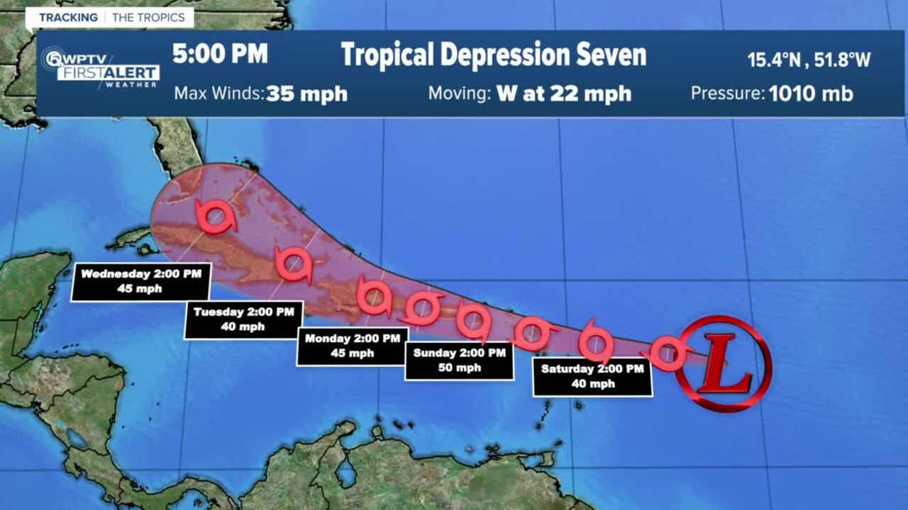
"Highly dependent on the track with the strength," Wieland said. "If it's a little farther north, it might be a lot stronger, rather than going through the islands."


