


WEST PALM BEACH, Fla. — According to the National Hurricane Center, Tropical Storm Fred has strengthened a little as it heads toward the western Florida Panhandle.
As of 4 p.m., the storm is moving north-northwest near 10 mph packing maximum sustained winds now near 45 mph with higher gusts.
On the forecast track, the center of Fred should move across the eastern and northern Gulf of Mexico through Monday, then make landfall in the western Florida Panhandle Monday afternoon or Monday night.
Fred is expected to bring heavy rainfall, possible flooding, and storm surge to the Florida Panhandle through Tuesday.
A Storm Surge Warning is now in effect along the Florida coast east of Steinhatchee River to Yankeetown.
A Tropical Storm Warning is in effect for the coast of the Florida Panhandle from Navarre to the Wakulla/Jefferson County line.
A Tropical Storm Watch is in effect for the Coast of the Florida Panhandle from the Alabama/Florida border to Navarre.
Fred is expected to make landfall in the Florida Panhandle Monday evening.

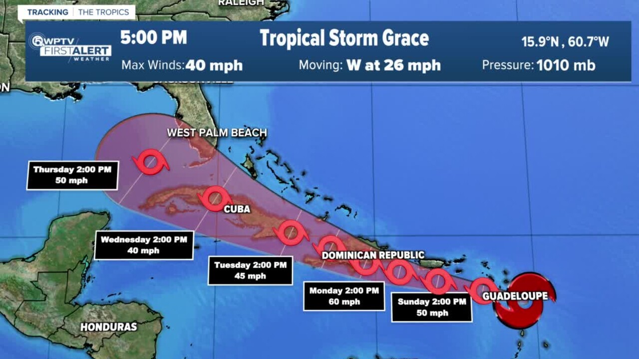
As of the 5 p.m. advisory, Grace has downgraded to a tropical depression as its maximum sustained winds have decreased to near 35 mph with higher gusts. The depression is moving toward the west-northwest near 15 mph.

On the forecast track, the center of Grace will move over Hispaniola on Monday, near or over eastern Cuba on Tuesday, and near or over west-central Cuba on Wednesday.
Most models keep Grace farther south, putting all of Palm Beach County and the Treasure Coast out of the storm's long-range cone of uncertainty next week. Any potential impacts in South Florida won't be felt until mid-week, forecasters said.
"We will likely see some impacts," WPTV First Alert Meteorologist Kate Wentzel said. "We are expecting a relatively typical summertime pattern of active storms each and every day."
Wentzel said Grace is expected to follow a similar track to Fred and thus could get sheared apart over the mountains of Hispaniola on Tuesday and Wednesday. She added that, as of now, Grace is not expected to intensify past a tropical storm.
"It could affect us here in South Florida as we head toward Thursday morning," said WPTV First Alert Meteorologist Steve Villanueva. "Winds at that time around 50 miles per hour."
Villanueva said most of the computer models keep Grace to the south of Florida and on the weaker side as it interacts with land and wind shear. He added that Grace will take the same track as Fred and will have lots of hurdles to deal with including landmasses and wind shear, so intensification will be limited.
TRACKING THE TROPICS: Hurricane Center | Hurricane Guide
Wentzel said there is also an area of low pressure near Bermuda with a 40% chance of development. there is no threat to South Florida but could increase swells late this week.
Meanwhile, a Flood Watch remains in effect for Palm Beach, Martin, St. Lucie, Indian River, and Okeechobee counties until 8 p.m. Sunday as the remnants of Fred pass to the west of Florida's peninsula.
Fred is forecast to make landfall in the Pensacola area on Monday.


